August 10th to 12th, 2010
Canyon De Chelly, Grand Canyon, The Petrified Forest and Sedona
After leaving Monument Valley, we drove to Kayenta, Utah where we stopped for burgers at Burger King for dinner. I hate to say it, but the town looks somewhat like it is in the Third World – the streets were covered with dark red mud and large puddles. The neighborhoods were full of junky cars and houses that had seen better days.
I was approached by a drunk, a Navajo man just a little younger than me, who proceeded to question me about what I thought about the Navajo and what my impressions of the Navajo Nation were. He then gave me a long, rather belligerent story about the Navajo Code Talkers of World War 2 fame. “Have you heard about them? What do you think about them?” Blah, blah, blah!
I was certain the drunk was going to try to beg money off me as several other men or women had tried to do at our gas station stops in larger towns.
Ahh!, the bad habits of druggies and alcoholics! Don’t you just love them?
The Navajo teenagers running the restaurant seemed deeply embarrassed and ashamed of the drunk. I got the impression that this guy spent his days hanging around begging from tourists as they got out of their cars at the Burger King. The end result of his efforts was that I bought him a combo meal and a coke.
The French family chastised me for being too generous - as my dad, their uncle, was in France. Dad had winos that would stop daily at his front door there in the little town in France where he lived in retirement to “borrow” a Euro or two. Dad would give them a little lecture about their drinking, but would always give them something.
After eating, we had to seek directions to find the right road to our next overnight stop, Chinle, Arizona which is near the Canyon De Chelly National Park.
By the way, De Chelly is pronounced “Dew Shay”
Chinle is in the heart of Navajo Nation Territory or treaty land. Again the area looked economically depressed and, after the day’s thunderstorm, it was awash in red mud. We stayed at the Best Western Motel.
The family had booked a morning jeep tour of the Canyon. I chose to stay and do all of our laundry at the Laundromat just across the highway from our motel. The guide arrived at 9AM with his jeep to take the Frenchies on their tour. I asked Mathieu, the youngest son, to bring my camera with him to take photos. He did a very admirable job with these photos.
 |
| Photo by Mathieu Jaeg-Desjardins |
 | |
|
 |
| Jaeg-Desjardin Family - Photo by Navajo Guide |
 | |
Petroglyph
|
The following material is from the National Park Service’s online brochure.
Canyon de Chelly National Monument
Reflecting one of the longest continuously inhabited landscapes of North America, the cultural resources of Canyon de Chelly include distinctive architecture, artifacts, and rock imagery while exhibiting remarkable preservation integrity that provides outstanding opportunities for study and contemplation. Canyon de Chelly also sustains a living community of Navajo people, who are connected to a landscape of great historical and spiritual significance. Canyon de Chelly is unique among National Park service units, as it is comprised entirely of Navajo Tribal Trust Land that remains home to the canyon community. NPS works in partnership with the Navajo Nation to manage park resources and sustain the living Navajo community.
 | |
|
 | |
|
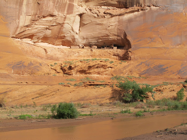
The place called Tseyi'
Millions of years of land uplifts and stream cutting created the colorful sheer cliff walls of Canyon de Chelly. Natural water sources and rich soil provided a variety of resources, including plants and animals that have sustained families for thousands of years. The Ancient Puebloans found the canyons an ideal place to plant crops and raise families. The first settlers built pit houses that were then replaced with more sophisticated homes as more families migrated to the area. More homes were built in alcoves to take advantage of the sunlight and natural protection. People thrived until the mid-1300’s when the Puebloans left the canyons to seek better farmlands.
 | |
|
 | |
|
Descendants of the Puebloans, the Hopi migrated into the canyons to plant fields of corn and orchards of peaches. Although the Hopi permanently settled on the mesa tops, the Hopi still hold on to many of their traditions that are evident from their homes and kivas.
 | |
|
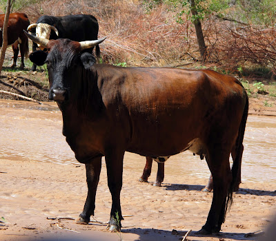
Related to the Athabaskan people of Northern Canada and Alaska, the Navajo settled the Southwest between the four sacred mountains. The Navajo, or Dine' as they call themselves, continue to raise families and plant crops just as the “Ancient Ones” had. The farms, livestock and hogans of the Dine’ are visible from the canyon rims.
 |
| Navajo Livestock - Photo by M. Jaeg-Desjardins |
Canyon de Chelly National Monument was authorized in 1931 by President Herbert Hoover in large measure to preserve the important archeological resources that span more than 4,000 years of human occupation. The monument encompasses approximately 84,000 acres of lands located entirely on the Navajo Nation with roughly 40 families residing within the park boundaries. The National Park Service and the Navajo Nation share resources and continue to work in partnership to manage this special place.
The family returned just before lunch - just as I came back to the motel with the clean clothes. We searched out a supermarket owned and operated by the Dine’ or Navajo to buy sandwiches and sodas for our lunch. We stopped at the picnic area at Canyon De Chelly to have our lunch before proceeding to our next destination.
The Painted Desert and the Petrified Forest
The desert was beautiful in the afternoon. We drove South to join Interstate 40 where we turned West. We left the Interstate for a short drive to see a giant meteor crater. I had seen this attraction many years before. The crater is very impressive, more than a mile across with a partial spherical crater that is over 1,000 feet deep. The crater is located on private land where there is an entry fee of $15 per person to allow visitors to stand on the rim of the crater. We decided that this was a bit steep, so we returned to the Interstate.
We came to the entry point for the Petrified Forest National Park. The park drive took us to several overlooks to view the colorful desert terrain.

We stopped at one view point where the foundation stones of a Puebloan building had been excavated.

Nearby were some petro glyphs. One of the drawings was of an egret with a frog in its beak…

Or. perhaps this was used as an example to the children! Can't you just hear the shaman as he brings the children out to the petroglyph?
”Behave or the great bird will snatch you up and fly you away!!”

The forest was buried in the mud and silt of from an ancient sea that flooded the area millions of years ago. The trees were buried in an airless environment that preserved them and allowed a chemical process to begin that replaced wood with minerals that turned into stone.


It is fascinating to see how the detail of the log’s tree bark is preserved in bark colored stone.

When the overlying earth and hard mud is washed away by wind and rain, more and more logs are exposed to view.

It is easy to conclude that the weather 200 million years ago was cooler and supported a type of redwood tree that we now see as petrified logs and tree trunks.

Before the Petrified Forest became a national park, early visitors to the area took great delight in taking away pieces of petrified wood. Trains on the Santa Fe railroad would stop before 1906 so that passengers could stretch their legs and gather petrified wood souvenirs. There was a commercial venture that gathered petrified logs to crush down to use the grit for making sandpaper!
All gathering of petrified wood in the park is now strictly forbidden and visitors’ cars may be inspected upon leaving the park.
It was almost dark when we left the Petrified Forest National Park. Our stop that night was at Holbrook, Arizona.
Grand Canyon National Park – The South Rim
Once again we visited a supermarket to buy delicatessen sandwiches and soft drinks before leaving Holbrook. We had our lunch at the picnic area by Desert View Tower in the park.

There were multitudes of tourists at Grand Canyon, most of them visiting families from Europe in rented cars like us. There were throngs of people visiting this area; it was difficult to find parking at all of our stops in the park. I fear that the time may come in my life time when a visitor will need a reservation to visit many of our National Parks.
The Frenchies and I used my National Park Senior Pass to enter the Parks – saving from $10 to $25 per entry as we followed our itinerary.
The following information is from the National Park Service.
Grand Canyon National Park
A powerful and inspiring landscape, the Grand Canyon overwhelms our senses through its immense size; 277 river miles (446km) long, up to 18 miles (29km) wide, and a mile (1.6km) deep.
Grand Canyon National Park is a World Heritage Site which encompasses 1,218,375 acres and lies on the Colorado Plateau in northwestern Arizona. The land is semi-arid and consists of raised plateaus and structural basins typical of the southwestern United States. Drainage systems have cut deeply through the rock, forming numerous steep-walled canyons. Forests are found at higher elevations while the lower elevations are comprised of a series of desert basins.

Well known its geological significance, the Grand Canyon is one of the most studied geologic landscapes in the world. It offers an excellent record of three of the four eras of geological time, a rich and diverse fossil record, a vast array of geologic features and rock types, and numerous caves containing extensive and significant geological, paleontological, archeological and biological resources. It is considered one of the finest examples of arid-land erosion in the world. The Canyon, incised by the Colorado River, is immense, averaging 4,000 feet deep for its entire 277 miles. It is 6,000 feet deep at its deepest point and 15 miles at its widest. However, the significance of Grand Canyon is not limited to its geology.

The Park contains several major ecosystems. Its great biological diversity can be attributed to the presence of five of the seven life zones and three of the four desert types in North America. The five life zones represented are the Lower Sonoran, Upper Sonoran, Transition, Canadian, and Hudsonian. This is equivalent to traveling from Mexico to Canada. The Park also serves as an ecological refuge, with relatively undisturbed remnants of dwindling ecosystems (such as boreal forest and desert riparian communities). It is home to numerous rare, endemic (found only at Grand Canyon), and specially protected (threatened/endangered) plant and animal species. Over 1,500 plant, 355 bird, 89 mammalian, 47 reptile, 9 amphibian, and 17 fish species are found in the park.
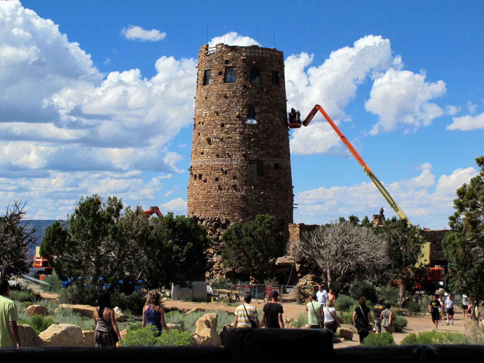
The Desert View Watchtower written by Park Ranger Brian Gatlin From Desert View… aptly named because of the views to the east of the Painted Desert…you can see the Colorado River make a big bend and continue to the west, the North Rim more than 10 miles away, and a panoramic view for well over 100 miles on a clear day. | |||||||||
|
The Desert View Watchtower is currently being renovated with Federal Stimulus Funds. The area has a nice gift shop, lunchroom, picnic area and clean restrooms.
There is a great sense of duration, age or the passage of time when one views and reflects on the Grand Canyon. I visited the Canyon when I was about 10 years old and have periodically visited throughout my life. During the span of my days, the Canyon has remained the same. However, as you look down at the layer upon layer of eroded stone, you realize that you are looking back at the abrasive process of hundreds of millions of years as the land slowly rises under the flowing river to expose each level of stone for our wonder.
We left the park and headed back South to Sedona, Arizona. I had never been there before.
Sedona, Arizona
We arrived in Sedona just before dark after a winding descent through Oak Creek Canyon from the high country around Flagstaff, Arizona.
The canyon reminded me a bit of the Ortega Highway from Lake Elsinore to San Juan Capistrano in Southern California – particularly the houses along the rushing creek that meandered down the canyon.
There were many beautiful homes along the creek the closer we got to Sedona. High over our heads were deep red sandstone cliffs glowing in the sunlight of the setting sun.

Our motel had a beautiful swimming pool which we used. Later, we ordered a pizza delivery for our dinner.
The next morning, we went into the town, which starts as the Oak Creek Canyon widens out. I was strongly reminded of Laguna Beach, California. There are lots of art galleries, souvenir shops, custom clothing boutiques, fancy restaurants and bars all through town. The town is very upscale and wealthy. We spent some time looking around the shops and then we explored some of the residential areas in and around Sedona.


We saw some very grand houses.

The biggest and obviously most expensive was located just across from the Church in the Rocks. I think that big house was only missing a heliport. It had an observatory!


We had a hard time finding the Church. There was a lot of roadwork near the junction of the road that lead to the Church.
Once we found it – Oh, my! What a beautiful location!

The architecture is dramatic and striking. The woman who designed it thought of it as a work of art she was making to glorify God. It truly is magnificent – a small jewel in an exquisite setting! I hope you enjoy my photos of this wonderful place.

We walked up to the Church to see the interior and to view the red sandstone formations and the Sedona area below.

Too soon we had to leave for our next stop in Phoenix, Arizona.
Next – Phoenix, Palm Springs and the Aerial Tramway
Thanks for reading. Your comments are welcome.
Traveler Al
Great blog!! Good stories and fun illustrations. Very nicely laid out. Thanks SK!
ReplyDelete